النص الكامل للفيديو
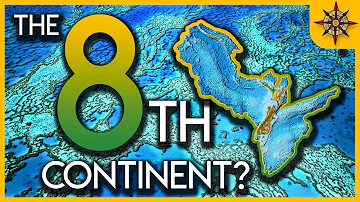
You’ve been lied to from the day you were first taught geography in school. Everyone has told you that there are 7 continents on planet Earth, but that is not entirely true. We’re about to do literal deep dive into one of Earth’s most mysterious lost continents: Zealandia. And unlike Atlantis. It’s real. And millions of years ago, it was part of much bigger story. In order to uncover the mysteries of Zelandia, we will need to have basic understanding of plate tectonics and general geology. Don’t worry, we’ve got you covered with everything you need to appreciate the magnitude of Zealandia and how it is changing the way we think about our world. Earth’s crust is always changing, and over very long periods of time, new landmasses form and others disappear. This is due to the fact that Earth’s crust is made up of numerous tectonic plates that are constantly smashing into, moving away from, or sliding against one another. For those of you who remember high school geology, these interactions are known as convergent, divergent, and transform plate boundaries, respectively. Due to these different processes, around 100 million years ago, Zealandia broke away from Antarctica, and approximately 20 million years later, another large piece of land broke away, which included current-day Australia. Then this plate broke apart once again, creating new continent which is now known as Zealandia. Today, Zealandia is about half the size of Australia—which is still pretty huge when you think about it—but there’s twist: somewhere between 93 and 95 percent of this lost continent is underwater. And since only tiny sliver peeks above the waves, it has only been recently discovered and classified by scientists. It is possible you have visited Zealandia without even knowing it. So, what land masses make up 7 percent of the continent above sea level? The majority of the land of Zealandia is made up of the Land of the Long White Cloud, or New Zealand. The South Island is the largest piece of Zealandian land above the ocean, followed by the North Island. Then there’s Stewart Island, and tons of tiny islets scattered around the western Pacific Ocean. The northern tip of Zelandia is made up of New Caledonia, group of islands governed by France. Even though most of it is underwater, scientists say Zealandia meets the geological criteria for continent: it’s large, distinct, has its own crust, and isn’t just fragment of another landmass. Basically, it’s not just submerged plateau or series of islands created by volcanic hotspots. We will go into more detailed analysis of how Zealandia fits these specific criteria later in the video, as this is hotly debated topic among scientists. We look forward to seeing how the Infographics Show Community feels about this topic in the comments section! But before things get too out of hand, let’s answer the question: where did Zealandia actually come from? Long before the world looked anything like it does today, there was mega-landmass called Gondwana. Gondwana covered about one-fifth of the Earth's surface. This supercontinent stretched over 100 million square kilometers, or approximately 38.6 million square miles. The remnants of Gondwana are actually still with us today. In fact, they make up two-thirds of the continents on Earth, including South America, Africa, Australia, and, of course, Zealandia. Now here’s where it gets interesting. Zealandia broke off from Gondwana during the final stages of the supercontinent’s breakup. Around 66 million years ago, during time geologists call the Paleogene, you could have walked between Antarctica, South America, and Australia using land bridges. However, sometimes between 66 and 23 million years ago, the land bridges began to crumble and Zealandia took its first steps to becoming its own continent. During the Oligocene Epoch, around 33.9 to 23 million years ago, the shifts in landmasses formed new ocean gateways like the Drake and Tasmanian Passages. Unfortunately, for anything living on what would become Zealandia at the time, the continent was fully submerged under the ocean, wiping out any species that could not swim. It was not good time to be Zealandian, but it wouldn’t be too long—geologically speaking, of course— until parts of Zealandia would re-emerge above the waves of the sea. At this point, you are probably starting to wonder how we could know so much about the ancient history of Zealandia when these events took place millions of years ago. The answer to this question, like so many others, is science! Geologists studied rocks in New Zealand and mapped out the sea floor around the islands. What they found was incredible—the land and seafloor in the region shared geological features with Western Antarctica, fitting the two land masses together like jigsaw puzzle. This proved that New Zealand and the surrounding landmasses weren’t your everyday recently formed islands—they were once part of the great Gondwanan landmass. And even though it broke off millions of years ago, Zealandia is actually considered the youngest continent on Earth. This is because the other 7 continents—North America, South America, Antarctica, Australia, Africa, Asia, and Europe, which we’re not completely convinced is an actual continent, but more on that later—formed long before Zealandia. So this brings us to the big question: how can Zealandia be considered continent when so much of it is under water? It will be very helpful to first understand what continent actually is. By definition, continent is large, continuous mass of continental crust, conventionally recognized as major region of Earth’s surface. It usually sits on its own tectonic plate, and is often, though not always which is key for understanding Zealandia, above sea level. So, really, when it comes to being continent, it’s not just about size—it’s about structure. Continental crust is thicker and less dense than oceanic crust, which is what causes it to “float” higher on the Earth’s mantle. This is because continental crust is made of less dense rocks like granite, while Oceanic crust is mostly basalt, which is denser rock. When classifying an area as continent, geologists typically look at four main things. The first is elevation. Is some of the region elevated above the surrounding ocean floor? Keep in mind this does not mean that the crust is above sea level, just that it is higher, and therefore less dense, than the oceanic crust around it. The second criteria is does the area have distinct geology, such as unique rock types and structures compared to other continents. Third, does it have well-defined boundaries that often correlate with plate boundaries? And lastly, is there coherence between the totality of the region meaning is the continent really one large piece of continental crust, or is it just scattering of islands? If landmass checks all those boxes, it’s continent! That being said, size matters too. Australia is the smallest traditional continent you’ve learned about, while Asia is the largest. However, many scientists consider Europe and Asia one giant continent—Eurasia—because they’re not separated by any clear boundary. This is also why we think it is difficult to make the argument that Europe and Asia are their own independent continents. Conversely, Zealandia doesn’t have this problem, which begs the question: is Zealandia more of continent than Europe? Again, we look forward to seeing the evidence-based debates unfolding in the comments of this video. It is worth noting that Greenland, which is really big and could be mistaken for continent, does not meet all of the criteria mentioned previously. This is because it sits on the same continental shelf as North America, and is made up of oceanic and continental crust mixed together. Therefore, although Greenland may look like continent from space, it is technically just an island that is part of the continent of North America. Let’s now go back to Zealandia. At first glance, it just looks like scattering of islands, none of which are very big. However, if we zoom out, much clearer picture starts to emerge. Zealandia didn’t just randomly sink—it was result of Late Cretaceous crustal thinning. That means the Earth's crust in this region stretched and thinned before Gondwana—the ancient supercontinent discussed earlier—broke apart. The process of crustal thinning caused the land to sink, or “subside,” into type of equilibrium between the amount of water in the oceans and land above sea level. Thanks to satellite gravity maps, marine expeditions, and data from New Zealand’s UNCLOS program, scientists now have more detailed view of what’s really below the waves of the Pacific. And what they see when they look at Zealandia is single, continuous block of continental crust, submerged due to current sea levels. And at 4.9 million square kilometers, Zealandia is about the same size as Greater India. It’s large, coherent, and formed from the same ancient roots as Gondwana, just like Africa, Antarctica, and Australia. What all of this means is that, according to current geological conventions, no rules need to change to make Zealandia continent. It checks all the boxes: size, structure, and history. That makes it the smallest, most submerged, thinnest, and youngest continent on the planet. That being said, there is an argument that Zealandia is not true continent but what is called microcontinent. Scientists who make this argument cite the facts that although elevation isn’t technically requirement for continent status, most recognized continents have significant landmass above water, while almost all of Zealandia is below sea level. They also argue that Zealandia isn’t perfectly unified block of crust, but rather fragmented collection of continental material stretched thin during the breakup of Gondwana. Basically, it is made up of pieces of several other continents. And due to the large amount of continental thinning Zealandia went through as it broke apart from Godswana, its crust is actually unusually thin when compared to other continents. In fact, it is almost halfway between what we’d expect to see for continental and oceanic crust. Therefore, these scientists are adamant that Zealandia is microcontinent, just like other small isolated pieces of continental crust surrounded by the ocean, like Madagascar or the Seychelles. Although it is worth noting that Zealandia is significantly larger than either of these microcontinents, and over twice the size of Greenland. Putting the classification debate aside, let’s discuss how Zealandia was discovered. There was no single event that led to Zealandia being identified as continent, but instead, it was series of discoveries over time. However, the term Zealandia wasn’t proposed until 1995, so this happened relatively recently. And to be fair, everything humans have ever done or discovered is recent in terms of geologic time. For decades, scientists suspected there was massive hidden continent beneath the Pacific Ocean. But proving it took an international scientific effort and few deep holes in the ocean floor. Enter the International Ocean Discovery Program Expedition 371, backed by the U.S. National Science Foundation and over 20 other nations. Their mission? Drill into the seafloor and uncover the secrets of Zealandia. And what they found was wild. Seafloor cores revealed that between 50 and 35 million years ago, Zealandia went through dramatic elevation changes. Parts of the northern region rose by 1 to 2 kilometers, while other sections sank about the same amount. And eventually, the entire continent slipped even deeper beneath the sea. But what caused all this vertical chaos? Researchers found that the Pacific Plate began subducting—or diving—beneath Zealandia. As the angle of this subduction increased, large piece of the continent broke off and sank. And as the scientists dug deeper, the discoveries compounded. The massive shift they were seeing wasn’t just local. It was part of global tectonic shake-up that most likely led to the Ring of Fire being formed around the Pacific Ocean. Along with the geologic evidence that connected Zealandia to events in the ancient past, sonar, seafloor mapping, and satellite data all helped to provide further evidence of the composition and structures of Zealandia’s boundaries and features. You can think of the cores that were drilled as boots on the ground evidence, while high-tech mapping provided the means to see the bigger picture. Now, scientists could zoom out from tiny fragment of rock to the boundaries and features that made Zealnadia unique. All of this evidence together was enough for many to declare Zealandia was, in fact, its own continent. Thanks to cutting-edge drilling, satellite data, and the hard work of international scientists, Zealandia is no longer just mystery beneath the waves; it’s textbook to better understand how the Earth really works. When scientists confirmed the existence of Zealandia, it didn’t just add new name to the list of continents; it flipped the script on what we thought we knew about the geology of the Pacific on its head. The Pacific region has always been one of Earth’s most geologically active zones. Around 90 percent of all earthquakes occur along the Ring of Fire, along with 75 percent of all active volcanoes on the planet. Zealandia sits at the intersection of several major plates and microplates. This helps explain the unusual seismic activity, puzzling crustal structures, and strange elevation changes across the continent. It also helps scientists understand how continents can stretch, thin, and sink while still maintaining cohesive continental crust. This is little understood beahviour of our planet’s crust and what we’re learning about Zealandia could help unlock other mysteries of our planet in the future. In particular, research around Zealandia might help scientists revise traditional models of how continents form and break apart. Along with giving us better understanding of the crust itself, Zealandia is also helping scientists get better grasp of continental drift: the slow-motion breakup of ancient supercontinents like Gondwana. By tracking how Zealandia split from Antarctica around 100 million years ago, and then from Australia 80 million years ago, researchers can reconstruct the way the global tectonic plates shifted over time. But wait—it gets even cooler. During the International Ocean Discovery Program Expedition 371, scientists drilled deep into Zealandia’s seafloor. The rock layers they pulled up weren’t just dusty old rocks—they were packed with fossils, sediment, and clues about Earth’s ancient climate. By analyzing the sediments and microfossils, scientists learned how ocean currents, temperatures, and ecosystems shifted along with the land in the region. The data uncovered in these cores could be huge deal for climate research as it helps us understand how continents affect global climate systems, and how past events could mirror changes happening today. So, Zealandia is more than just sunken continent. It’s time capsule, giving scientists glimpse into the mechanics of plate tectonics, the journey of drifting continents, and even the forces that shaped Earth’s atmosphere and oceans. Zealandia’s discovery showed that even something as massive as 4.9 million square kilometer continent can go unnoticed for centuries, until the right technology comes along. So it stands to reason: what other secrets are waiting to be found? The most obvious answer to this question is more hidden continents. What if there are other landmasses to be found just like Zealandia? Or perhaps in the future, scientists will discover more microcontinents or fragments of ancient supercontinents like Mauritia under the Indian Ocean, or Argoland near Southeast Asia. Maybe there is even an entirely new undiscovered continent just under the waves of the ocean, rivaling the size of Zealandia itself. We just won’t know until more of the ocean floor is mapped and we have more data on the composition of seabeds across the planet. But there might also be something bigger out there. For instance, as recently as 2020, scientists have found evidence for an entirely new tectonic plate. This undiscovered piece of the Earth had been buried beneath Canada and has become known as the Resurrection Plate. Scientists had hypothesized the existence of this lost plate, but it took decades of research, modeling, and reverse engineering to identify the location of the Resurrection Plate. So, perhaps there are more “ghost plates” buried deep in the Earth’s mantle that could reshape our understanding of how continents form and shape the surface of our planet. It may seem like something out of sci-fi movie, but scientists have discovered millions of species living in what is called the deep biosphere. Basically, these are ecosystems kilometers below the surface, living inside rocks and thriving without sunlight. Some scientists think around 60% of Earth’s species live underground, some in places hotter and more pressurized than we thought life could even exist. Knowing this, is it possible that there are deadly bacteria that could lead to the next global pandemic lurking deep below Earth’s surface? What if the next mining operation digs up more than just precious minerals? Then again, maybe these organisms could lead to the next big cure or to better understanding of how life evolved on Earth. We just won’t know unless we continue launching expeditions similar to those that discovered Zealandia. Recent seismic studies suggest there are giant hidden structures in the Earth’s mantle called Large Low-Velocity Provinces, some of which are larger than the continents themselves. Currently, scientists have no idea what these gigantic sunken structures are. Some believe they might be the remains of an ancient planet that collided with Earth. Or perhaps they are piles of ancient subducted crust. Whatever the Large Low-Velocity Provinces are, one thing is clear: they’re huge, and they don’t behave like anything else inside the planet. This just goes to show that our planet still holds mysteries, and like with Zealandia, it will take brilliant minds and lot of work to understand what mysteries are locked inside our planet. It is believed that less than 1% of the lifeforms that lived on Earth have been found in the fossil record. To be fair, an organism needs to have died in very specific environment long time ago for their remains to become fossilized, but even still, the fossils we have discovered likely only represent fraction of the fossils still hidden beneath the surface of the planet. From the Sahara to Antarctica, there are still entire regions where no one has ever dug for fossils. It is inevitable that in the future we will find new species in the fossil record. We might uncover evidence of an unknown human ancestor, never-before-seen dinosaur fossils, or something so strange that it changes the way we think life evolved on our planet. With tools like LIDAR, ground-penetrating radar, and AI-powered dating methods, the next century of Earth science and paleontology could completely change the story of life on this planet. Who knows, maybe the next big fossil discovery will come from Zealandia. Zealandia reminds us that there is still so much we don’t know about our planet, and there are plenty of mysteries yet to be solved. Over 80% of the seafloor remains unmapped and unexplored at high resolution. That’s like trying to understand Earth’s surface with most of the lights turned off. To put this into perspective, we have mapped the entirety of the Moon’s surface and only about 20% of our own oceans. Recently, the USGS Astrogeology Science Center, in collaboration with NASA and the Lunar Planetary Institute, created the Unified Geologic Map of the Moon. This detailed map allows scientists to scrutinize the surface of our closest celestial body in great detail. However, we have yet to do the same thing for our own planet. We now have the technology to map the seafloor and uncover untold mysteries. The problem is that we have to want it. Even though detailed mapping expedition for our planet similar to the Unified Geologic Map of the Moon is possible, it would be expensive. But can you really put price on gaining better understanding of the only world we have? We think not. Zealandia is just the beginning. The next big discovery could be lurking just beneath the ocean or deep in the Earth’s crust. We just won’t know until we look. The Earth is still revealing its secrets, and what we thought we knew about the continents on our maps and the science behind them is constantly shifting. Next time you visit one of the islands of Zealandia, remember you’re standing on the highest point of hidden continent, lost beneath the waves that was once part of one of the biggest landmasses Earth has ever known. Now watch “Most INSANE Unsolved Mysteries Explained in 30 Minutes.” Or check out “This Super Volcano Has Scientists Freaking Out.”

 7:41
7:41
 28:34
28:34
 9:10
9:10
 16:39
16:39
 7:43
7:43
 3:06
3:06
 1:17
1:17
 5:26
5:26


